Barbados Cloud Observatory
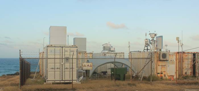
The Barbados Cloud Observatory (BCO) is located on the windward coast of Barbados and is well situated to observe the air masses carried by the trade winds over the Atlantic Ocean. The site, which has been in operation since April 1, 2010, is equipped with standard meteorological instruments (measuring e.g. temperature, humidity, pressure, wind, rain rate, solar irradiance) and several remote sensing instruments to study the vertical distribution of overpassing clouds as a function of the large-scale environment. For the EUREC4A campaign, the BCO provides the long-term context for intensive observations, which will be combined with measurements from other platforms to achieve the campaign objectives. (photo credit: Sabrina Schnitt)
Find lots of actual information about the BCO here:
https://barbados.mpimet.mpg.de/
Coordinates
The BCO is located at 13°9′45.5″N, 59°25′43.5″W 17 m altitude above mean sea level (doi:10.1175/BAMS-D-14-00247.1). More coordinate data on this separate page.
Instrumentation
| Raman lidars: | Three generations of MPI-M Raman lidars were sequentially deployed at BCO since April 2010. Different in capabilities each lidar in the row has been built with very similar conceptual design dedicated for upward profiling of air temperature and humidity as well as for mapping vertical stratification of clouds and aerosol properties at three wavelength of frequency tripled Nd:YAG laser emission (1064, 532, and 355 nm). |
| CORAL cloud radar: | Upward looking polarized Doppler cloud radar to detect radar reflectivity, Doppler velocity and linear depolarization ratio of cloud particles. The radar is operating with a frequency of 35 GHz and has a sensitivity of -48 dBZ at an altitude of 5 km and -70 dBZ at an altitude of 500 m. It measures a vertical range between 150 m and 18.9 km with a vertical resolution of 30 m. The Doppler resolution is < 0.02 m s-1 between -10 m s-1 and 10 m s-1. Data are available since April 2015 with a temporal resolution of 10 s (2 s since July 2018). Data from a former radar with similar characteristics but a lower sensitivity are available since December 2010. |
| W-Band cloud radar: | Upward looking polarized Doppler 94 GHz cloud radar to detect radar reflectivity, Doppler velocity and linear depolarization ratio of cloud particles. The W-Band radar is measuring since December 2018 at altitudes between 150 m and 15 km with a temporal resolution of 2 s. |
| Doppler Lidars: | One upward looking (since July 2015) and another horizontal scanning Doppler lidar (since February 2019) to measure vertical and horizontal wind speed. Both instruments use a laser beam with a wavelength of 1500 nm to measure at an altitude between 50 m and ~1000 m. The temporal resolution of the vertical wind speed is 1.3 s. Horizontal wind speed and direction are averaged over an interval of 2 minutes. |
| Microwave radiometer: | Humidity and temperature profiling radiometer (HATPRO). Two bands, 22 - 31 GHz and 51 - 58 GHz. The vertical resolution is less than 40 m in the sub-cloud layer with a temporal resolution of ~1 minute. Data from the current microwave radiometer are available since April 2017. Data from a former microwave radiometer are available since January 2011. |
| Micro-Rain-Radar: | Upward looking 24 GHz Micro-Rain-Radar to detect fall velocity of hydrometeors and rain rate. Both parameters are measured at an altitude between 100 m and 3 km with a temporal resolution of 1 Minute. Data are available since April 2010. |
| Ceilometer: | The Ceilometer is using a non-visible laser beam with a wavelength of 1064 nm to detect the cloud base height up to ~10 km. It is running since 2010 with a temporal resolution of 10 s. |
| Radiation: | Pyranometer, Pyrgeometer and Pyrheliometer for radiance and irradiance measurements. The temporal resolution is 1 s and the instruments are running since April 2015. |
| Weathersensor: | Four meters above ground, several sensors measuring pressure, temperature, humidity, precipitation, wind speed and wind direction since December 2010 with a temporal resolution of 10 s. |
| Disdrometer: | Detects drop size distribution and velocity of falling hydrometeors. Data are available since May 2017. |
| Allsky and Thermal Imager: | The Allsky-Imager uses a fish-eye objective to take a picture every minute of the entire sky. The center part of the picture is also covered by an IR-Camera, which detects the temperature at the cloud base. Pictures of the Allsky-Imager are available since 2010. The thermal camera has taken pictures since the end of 2018. |
| Webcam movies: | A camera located at Ragged Point faces towards the easterlies and shows the daily weather situation in the vicinity of the Barbados Cloud Observatory. The daily movies are available since February 2010. |
| Radiosoundings: | Sounding Data supports our field experiments and also servers as a reference by calibrating Raman lidars for air temperature and humidity output. The radio sounding station records temperature, humidity, pressure, wind speed and wind direction from radiosonde launched with weather balloon. The sounding data digitized with 1 second interval and covers typically a range from ground up to 29 km altitude, that corresponds to about two hours of balloon ascending. The radio sounding station has ever operated manually by MPI-M staff or colleagues from partner institutes. Sounding data is available since 2010. |
References
Stevens, B., et al., 2016: The Barbados Cloud Observatory — anchoring investigations of clouds and circulation on the edge of the ITCZ. Bulletin of the American Meteorological Society, 97, 787-801 , https://doi.org/10.1175/BAMS-D-14-00247.1
